Geospatial Analytics
We enable the research processes of the HSRC through Geospatial Analytics services:
• We conceptualise spatial components of the research process.
• We ensure geographical representivity in sample designs.
• We conduct spatial analysis and modelling, as well as spatial and GIS research.
• We provide GIS services and spatial data.
Clients contact us when they require
• a master sample,
• fieldwork survey maps,
• spatial analysis and modelling,
• accessibility modelling,
• research results to be visualised in a map,
• training in data visualisation and GIS, and
• assistance with spatial conceptualisation in the research process.
Projects
Labour Centre GIS
We worked with the Department of Labour (DoL) in the development of a GIS database of labour centres in South Africa. The importance of labour centres as a foundation in addressing supply and demand aspects of the labour market underlay this study. It was for this reason that the HSRC provided some funding for the initial capturing of the spatial location of labour centres, visiting points and satellite centres throughout the country.
The DoL and the HSRC recognized that this project created an important foundation for the creation of an integrated Labour Market Information and Statistics (LMIS) system for the Department.
The objectives of the project were to:
- Geo-locate all labour centres, visiting points and satellite centres related to labour centres in South Africa;
- Create catchment areas for each labour centre (i.e. define their areas of influence/administration) and its associated visiting points and satellite centres. This was done by using sophisticated GIS algorithms i.e. Voronoi regions. The catchment area boundaries were then reconciled with existing administrative boundaries, such as the municipalities;
- Integrate statistics collected at the labour centres and other data sets (e.g. demographics) into the GIS.
Eastern Cape Land Claims
The HSRC was commissioned by the Chief Directorate: Spatial Planning and Information of the previous Department of Land Affairs (DLA) to map 410 priority claims in the Eastern Cape. The intention of the project was to provide spatial and attribute information for each of the land claims and to make recommendations on the sustainable use of the land from a developmental and land capability perspective.
The main objectives of the project were to:
- Map the settled and priority rural and large urban community land claims identified by the Regional Land Claims Commissioner;
- Provide spatial information that would enable the claimed land to be linked into other initiatives and economic activities best suited to the land’s location and potential;
- Give a better understanding of what type of land is being claimed, where it is located within a local municipality and it’s Integrated Development Plan, which incorporates its Spatial Development Framework, and what possible economic opportunities the claimants could link into.
The project was able to provide an understanding of the geographical location and extent of each land claim. By integrating this information with many other spatial layers of information and attributes associated with each land claim, an understanding was obtained for the first time on the suitable of the land for developmental and agricultural uses. Consequently, this information enabled the DLA to provide broad guidance to beneficiaries on the optimal and sustainable use of the land and for inputs into the monitoring and evaluation of the land in the future.
Citizen Report Card Survey
The Citizen Report Card is an instrument that provides important feedback on the adequacy, efficiency and quality of services from actual users of public services. This study was commissioned by The World Bank and undertaken by the then GIS Centre and the Democracy & Governance research programme of the HSRC. Two pilot studies were undertaken:
- Metropolitan area of South Africa – City of Tshwane
- Rural area – OR Tambo District Municipality
The aim was to research levels of satisfaction with service delivery, identify priority services and target areas, establish accountability mechanisms between citizens and municipalities and lastly to enable the monitoring of municipalities’ delivery of core services. The surveys collected information on the following topics:
- Access to services
- Payment for services
- Billing for services
- Amount of free basic services received
- Complaints about services
- Satisfaction with services
- Perceptions on the municipality
Land Size And Efficiency Simulation (LSES)
This multi-stakeholder led project is funded by the UNDP and the team includes the Economic Performance & Development (EPD), Geospatial Analytics of the HSRC together with the International Food Policy Research Institute (IFPRI) in Washington.
The objective of the project is to determine the economic impact of the Regulation of Agricultural Land Holding Policy and Bill (RALHB). The research team is expected to provide technical expertise in project planning and implementation, develop a Land Size and Efficiency Simulation (LSES) model to test the socio-economic implications of (RALHP) in the South African economy and project administration. Findings of the LSES model will inform the Preservation and Development of Agricultural Land Framework (PDALF).
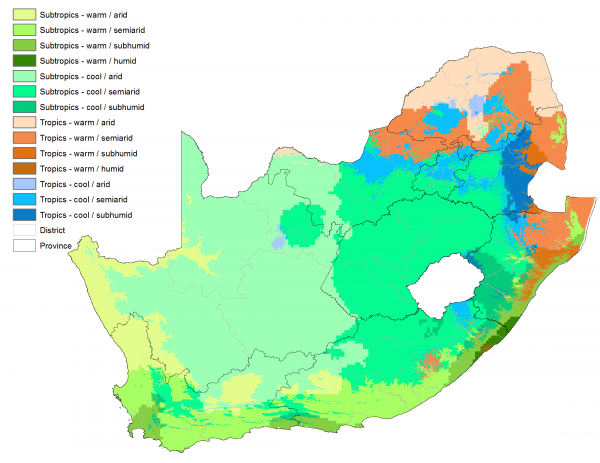
The Geospatial Analytics team contributed by sourcing, mapping and analysing the spatial datasets that were relevant to the project e.g. climate, agri-hubs, grazing capacity of the land, water rights and land and soil capability just to mention a few. One of the resulting datasets is shown below.
Rural Innovation Assessment Toolbox (RIAT) Mapping
This study was undertaken by the Geospatial Analytics unit together with the Economic Performance & Development (EPD) research programme of the HSRC on behalf of the then Department of Science and Technology. The Rural Innovation Assessment Toolbox (RIAT) was designed to understand rural people’s experiences and activities related to innovation in South Africa. Such experiences and innovation activities in eight rural district municipalities were recorded from surveys in 2011, 2012 and 2016. Innovation was broadly defined as activities including:
- Invention
- Adoption
- Adaption/adjustment and
- Diffusion
The Geospatial Analytics unit cleaned the survey data and converting it to enable GIS thematic mapping. The maps were produced using ArcMap and put into an ArcReader format to enable municipal officials to use the maps without having to purchase GIS software. Furthermore, we trained 54 municipal officials in four District Municipalities to use, interrogate, map and analyse the findings.


